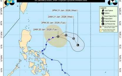
Tropical Depression Ada (international name Nokaen) held its intensity early Tuesday morning as it moved further east of Aurora, though weather forecasters expect the storm to weaken into a low-pressure area (LPA) by Wednesday.
In its 5:00 a.m. bulletin, the Philippine Atmospheric, Geophysical and Astronomical Services Administration (PAGASA) reported that “Ada” was packing maximum sustained winds of 55 kilometers per hour (kph) near the center, with gusts reaching up to 70 kph.
The storm was last located 675 kilometers east of Casiguran, Aurora, moving eastward at 20 kph.
While no tropical cyclone wind signals are currently in effect, PAGASA warned that the northeast monsoon, or amihan, continues to bring strong to gale-force gusts across several regions. Impacted areas include:
• Northern Luzon: Batanes, Babuyan Islands, Ilocos Norte, Ilocos Sur, Abra, and parts of Cagayan and Isabela.
• Central and Southern Luzon: Aurora, Calabarzon, Marinduque, Romblon, and both Oriental and Occidental Mindoro.
• Visayas and Mindanao: Bicol Region, Northern Samar, Samar, Eastern Samar, and Dinagat Islands.
A gale warning remains active for the northern seaboards of Northern Luzon due to hazardous sea conditions.
PAGASA remains optimistic that the tropical depression will lose its strength within the next 24 hours, transitioning into an LPA as it continues its track away from the Philippine landmass.