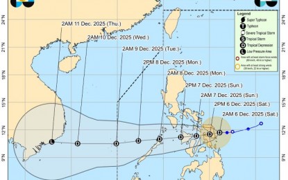
Tropical Depression (TD)Wilma has slightly accelerated its westward path and is now poised to make landfall over Eastern Visayas sometime today, Saturday, according to the latest bulletin from the Philippine Atmospheric, Geophysical and Astronomical Services Administration (PAGASA).
As of the 5 a.m. monitoring, the center of Wilma was pinpointed 70 kilometers east of Borongan City, Eastern Samar. The tropical depression is currently moving at 15 kilometers per hour (kph) and maintains maximum sustained winds of 45 kph near the center with gustiness up to 55 kph.
The weather disturbance is expected to traverse the Visayas region through Sunday. Following its passage, it is forecast to emerge over the Sulu Sea and may track over northern Palawan by Monday morning.
PAGASA projects Wilma to remain at tropical depression strength throughout its movement over the central and southern parts of the country.
In preparation for the impending weather, Tropical Wind Signal No. 1 remains hoisted over a broad swathe of provinces across Luzon, Visayas, and Mindanao.
Signal No. 1 Areas Include:
• Luzon: Sorsogon, Masbate (including Ticao and Burias Islands), Romblon, the southern portions of Oriental and Occidental Mindoro, and the northernmost portion of Palawan (including Cuyo, Calamian, and Cagayancillo Islands).
• Visayas: All provinces in Eastern Visayas (Northern Samar, Eastern Samar, Samar, Biliran, Leyte, Southern Leyte), Cebu, Bohol, Negros Occidental, Siquijor, the northern and central portion of Negros Oriental, Guimaras, Iloilo, Capiz, Aklan, and Antique.
• Mindanao: Surigao del Norte (including Siargao and Bucas Grande Islands), Dinagat Islands, the northern portion of Surigao del Sur and Agusan del Norte, and Camiguin.
PAGASA warns that areas under the tropical cyclone wind signal, as well as those affected by the prevailing shear line (Bicol Region, Quezon, Occidental Mindoro, Oriental Mindoro, and Marinduque), should prepare for rains and gusty winds.
Moderate to heavy, and at times intense, rainfall poses a significant threat of flash floods and landslides, urging residents in low-lying and mountainous areas to remain vigilant and heed local disaster risk reduction and management office advisories.