Severe Tropical Storm Fung-Wong has intensified significantly over the Pacific Ocean and is on track to enter the Philippine Area of Responsibility (PAR) by midnight or early Saturday morning, according to the Philippine Atmospheric, Geophysical and Astronomical Services Administration (PAGASA).
Once inside PAR, the weather disturbance will be locally named Uwan. The storm poses an increasing threat as weather models project it will undergo rapid intensification, potentially reaching Super Typhoon category before making landfall early next week.
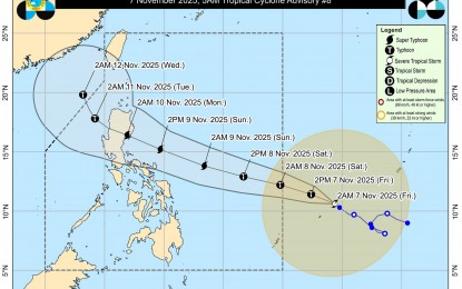
As of Friday, the storm was classified as a Severe Tropical Storm, located roughly 1,500 kilometers east of Northeastern Mindanao, packing maximum sustained winds of 95 kilometers per hour (km/h) near the center and gustiness of up to 115 km/h. It is moving northwestward at a relatively slow pace of 10 km/h. Its gradual approach is allowing forecasters to monitor its projected explosive intensification over the weekend as it draws closer to the archipelago.
“The system may rapidly intensify into a typhoon within 24 hours and could reach the super typhoon category by Saturday evening or Sunday morning,” PAGASA stated in its latest bulletin. The weather bureau cautioned that the storm’s projected path shows it may make landfall over Northern or Central Luzon on Monday, hitting the region at or near its peak intensity, which could be catastrophic for communities along the coast and inland.
In anticipation of the storm’s entry and intensification, PAGASA has warned that Tropical Cyclone Wind Signals (TCWS) may be raised over the eastern portions of Luzon and the Samar provinces as early as Friday afternoon or Saturday morning. Under the current forecast, the highest possible alert level is Signal No. 5, indicating a severe threat to life and property from extremely powerful winds and torrential rainfall associated with a Super Typhoon.
Weather conditions are expected to begin deteriorating as early as Sunday, with the main impact predicted for the start of the work week. PAGASA warned that potentially life-threatening stormy conditions could grip Northern and Central Luzon on both Monday and Tuesday. Residents in these areas are advised to finalize disaster preparedness plans, secure homes, and be ready for immediate evacuation protocols should they be implemented by local government units.
The storm will severely affect marine travel and operations throughout the country’s eastern seaboards. Moderate to rough seas are already expected over the northern and eastern seaboards of Luzon and the eastern seaboards of Visayas and Mindanao beginning Friday or Saturday. This will escalate to “very rough to phenomenal seas” across most of Luzon and Eastern Visayas from Sunday onwards, making all maritime activities hazardous and warranting the suspension of voyages.