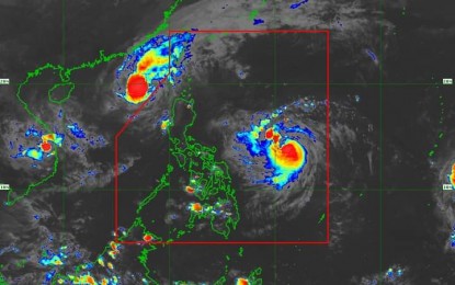

MANILA – Nika (international name Toraji) left the Philippine Area of Responsibility around 2 p.m. Tuesday, the Philippine Atmospheric, Geophysical and Astronomical Services Administration (PAGASA) said.
However, Ofel (international name Usagi) has intensified into a severe tropical storm, packing maximum sustained winds of 95 kph near the center and gustiness of up to 115 kph.
It was located 780 km. east of Virac, Catanduanes as of 4 p.m.
Ofel could bring strong to gale-force gusts across Catanduanes, and heavy rains over some parts of Northern Luzon on Wednesday.
“There is a minimal to moderate risk of storm surge with peak surge heights of 1 to 2 meters in the next 48 hours over the low-lying or exposed coastal localities of eastern mainland Cagayan, Isabela, and northern Aurora,” PAGASA said in a 5 p.m. bulletin.
In Tuesday’s episode of Bagong Pilipinas Ngayon, PAGASA hydrologist Elmer Caringal said major dams in Luzon might continue the gradual release of water, in anticipation of the upcoming rainfall due to Ofel and another cyclone entering PAR in a few days.
“Release is gradual since water is needed for generation, irrigation. Also, the decision on how to control the dams’ (water level) is up to their management,” he said.
Ofel is forecast to make landfall over the east coast of Cagayan or Isabela on Thursday, PAGASA said. (PNA)