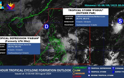
The low-pressure area (LPA) west of the Ilocos Region has intensified into a tropical depression (TD) named Fabian, according to the weather bureau on Friday.
As of 10 a.m., Fabian was located 185 kilometers west of Batac, Ilocos Norte, and is moving northwestward at a speed of 10 kilometers per hour (kph).
The Philippine Atmospheric, Geophysical and Astronomical Services Administration (PAGASA) forecasts that the tropical depression will exit the Philippine Area of Responsibility (PAR) tonight or early Saturday.
Fabian is packing maximum sustained winds of 45 kph near its center, with gustiness reaching up to 55 kph. It is expected to maintain its strength until it weakens into a remnant low as it exits the PAR.
Currently, no tropical cyclone wind signal has been hoisted, and the tropical depression is unlikely to directly impact the weather conditions in the country.
However, PAGASA has warned that Fabian will generate moderate seas in the coastal waters of Northern Luzon. Mariners of motor bancas and similarly sized vessels are advised to take precautionary measures while venturing out to sea.