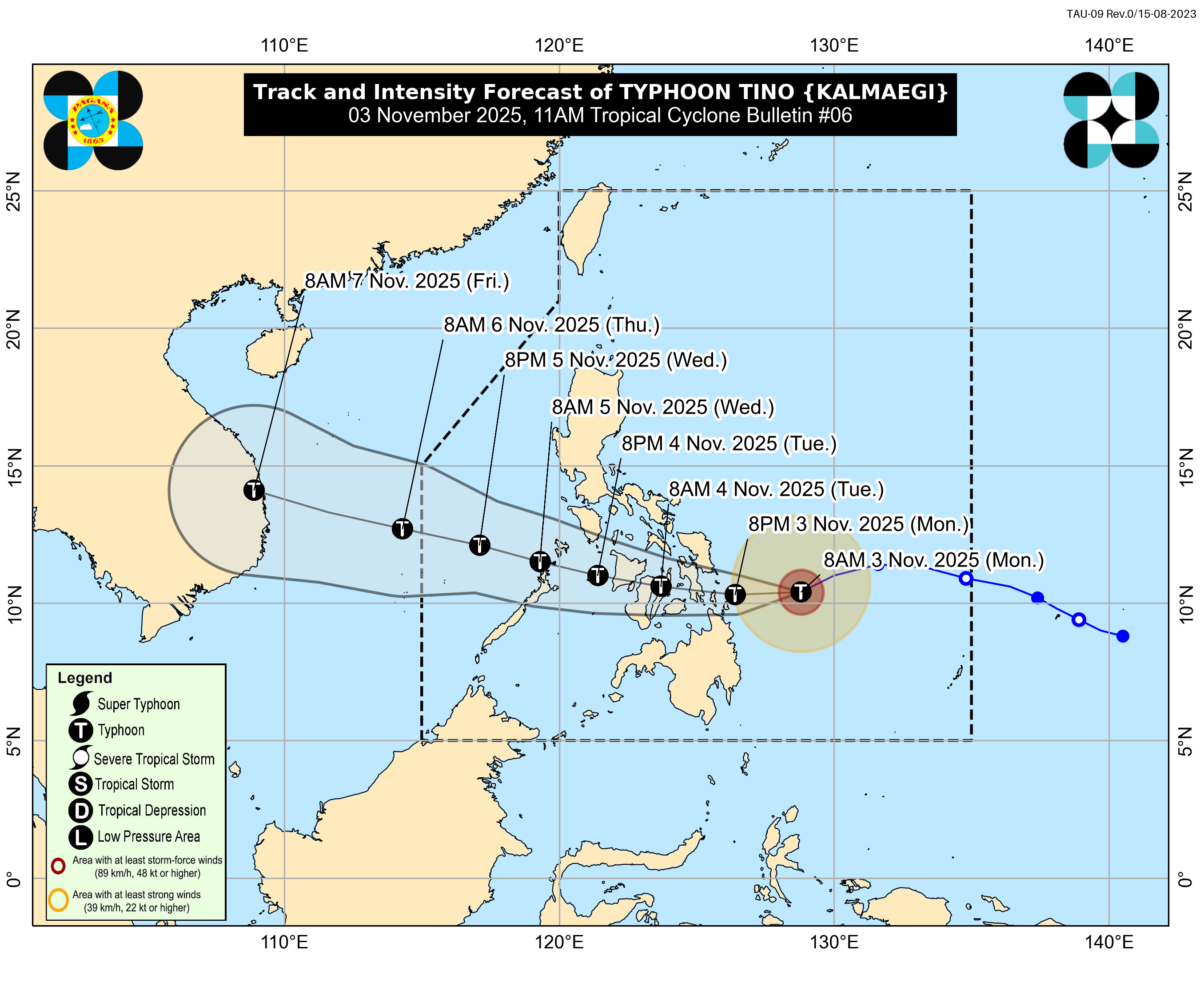
Severe Tropical Storm Tino (international name: Kalmaegi) has strengthened into a typhoon as it continues to move closer to the eastern seaboard of the Philippines, the state weather bureau announced Monday morning.
According to PAGASA, Tino reached typhoon status around 8 a.m., with maximum sustained winds of 120 kilometers per hour and gusts reaching 150 km/h. The weather system was last located about 340 kilometers east-southeast of Guiuan, Eastern Samar, within the Philippine Area of Responsibility (PAR).
The typhoon is currently moving west-southwestward at 25 km/h, and is expected to continue heading toward the Visayas region.
Signal No. 3 Areas
Tropical Cyclone Wind Signal (TCWS) No. 3 remains hoisted over the southeastern portion of Eastern Samar—including Guiuan and Mercedes—and Dinagat Islands, Siargao, and Bucas Grande Islands.
Signal No. 2 Areas
Signal No. 2 covers several provinces in the Visayas and Mindanao, including:
• Central and southern portions of Eastern Samar and Samar
• Leyte, Southern Leyte, Biliran, Bohol, and large parts of Cebu (including Bantayan and Camotes Islands)
• Northeastern Negros Occidental, Surigao del Norte, northern Surigao del Sur, and northeastern Agusan del Norte
Signal No. 1 Areas
Meanwhile, TCWS No. 1 is in effect in wide portions of Luzon, Visayas, and Mindanao—covering Sorsogon, Masbate, Albay, Romblon, Marinduque, Mindoro provinces, and island groups such as the Cuyo and Calamian Islands. It also includes Northern Samar, the remaining parts of Eastern Visayas, Cebu, Negros Island, Panay, Camiguin, Misamis Oriental, and parts of Bukidnon.
Possible Landfall and Impacts
Based on PAGASA’s latest forecast track, Tino may make its first landfall between late Monday night and early Tuesday morning over the southern portion of Eastern Samar, Leyte, Southern Leyte, or Dinagat Islands. After crossing parts of the Visayas, the typhoon is projected to move toward northern Palawan and exit into the West Philippine Sea by Wednesday.
The weather bureau also issued a storm surge warning, cautioning residents in coastal areas of the Visayas and Mindanao about the risk of life-threatening surges exceeding three meters within the next 48 hours.
Communities under cyclone signals were urged to stay alert for strong winds, heavy rainfall, flash floods, and possible landslides as Tino continues to intensify